What was it like when four hurricanes tormented Florida? Let’s take a look
The 2024 hurricane season starts June 1 and ends Nov. 30, and forecasters expect a “hyperactive” year of storms.
Way back in 2004, four hurricanes made landfall in Florida — Charley, Frances, Ivan and Jeanne — the most recorded for the state in a single year.
That Atlantic hurricane season was a hyperactive beast, killing more than 3,200 people across the world and causing more than $61 billion.
Of the 16 named storms — from Alex to Otto — nine brushed or struck the United States, according to the National Hurricane Center, including, of course, Florida’s fearsome four.
From the Miami Herald archives, here is some of what happened during that mean season two decades ago:
A look back at the storms
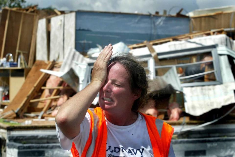
Hurricane Charley
Nearly a million Floridians told ‘Leave!’
Published Aug. 13, 2004
Authorities urged 800,000 Floridians to flee their homes Thursday, a mammoth evacuation that came as Hurricane Charley intensified and began mushrooming into a monster storm that gravely imperiled Florida’s Gulf Coast.
The double-barreled danger: winds stronger than 115 mph and a wall of seawater up to 13 feet high, especially in the Tampa Bay area.
“This really is our nightmare scenario,” state meteorologist Ben Nelson told Gov. Jeb Bush and other officials who met late Thursday in the state’s Emergency Operations Center in Tallahassee.
The Florida National Guard began moving soldiers to Tampa late Thursday. About the same time, with Charley just over the horizon, Key West officials issued a last-minute plea: Evacuate the first floor of buildings in areas closest to the sea.
The storm’s projected path once it crosses Cuba shifted slightly westward, diminishing the threat to Miami-Dade and Broward counties but enhancing the hazards confronting Tampa, St. Petersburg and other flood-prone regions along Florida’s Gulf Coast.
Forecasters said Charley’s outlying squalls could touch South Florida today, with 35 mph winds and two to five inches of rain, though some areas could receive more. They also warned that tornadoes were possible. A flood watch covered the region until at least 8 p.m.
At the northern end of the state, Tropical Storm Bonnie brought wind and rain to the Panhandle, but Charley by far was the most dangerous of the two storms that endangered the state.
Throughout the Keys and Gulf Coast — in fact, throughout much of the state — an atmosphere of crisis and foreboding prevailed.
After carving through Cuba - raging nearly over Havana - and passing close to Key West, Charley’s central core could reach Florida’s mainland as a major Category Three storm, with winds of 115 mph. Then, forecasters said, strong wind could cut a path through Central and Northeast Florida.
Hurricane Frances
Frances prep tests South Floridians’ patience
Published Sept. 3, 2004.
By nightfall Thursday, scores of South Florida gas stations had run out of gas. Sheets of plywood were a scarce commodity.
Many stores were out of C and D batteries and water jugs. Cash machines had run dry.
Hurricanes always set off a run on gas, water and supplies. But Hurricane Frances poses a unique set of problems. It comes three weeks after Hurricane Charley, a storm that lowered inventories and raised fears across the state. And given the size of this storm, customers up and down Florida were looking for the same things.
The shortages left even hurricane-savvy residents startled.
“I feel like a scavenger, picking things off the floor and searching for anything,” said Claudio Nino, 35, who spent the day at a Wal-Mart in West Dade. “There aren’t even any potato chips left here.”
Gas seemed the scarcest of all. Florida’s two main gasoline ports were closed to tanker ships for safety reasons. Along U.S. 1 and U.S. 441 and other arteries in wide swaths of Miami-Dade and Broward, service stations wrapped yellow tape around dry pumps and shut down until further notice.
It could be Sunday or later before supplies are replenished, a prospect that might make Frances’ aftermath that much more frustrating.
One of the few stations still open late Thursday was the Shell on Northwest 12th Street and 87th Avenue. Scores of cars waited for at least 45 minutes, backing up traffic for 20 blocks.
“I’m so nervous, because they might run out of gas before I get there,” said Nery Ng, 22, of Doral.
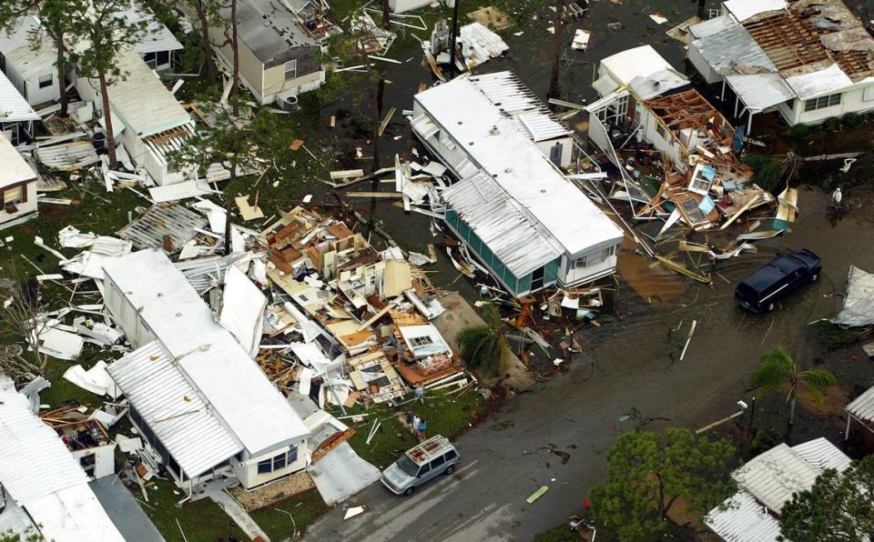
Frances batters the Treasure Coast
Published Sept. 5, 2004
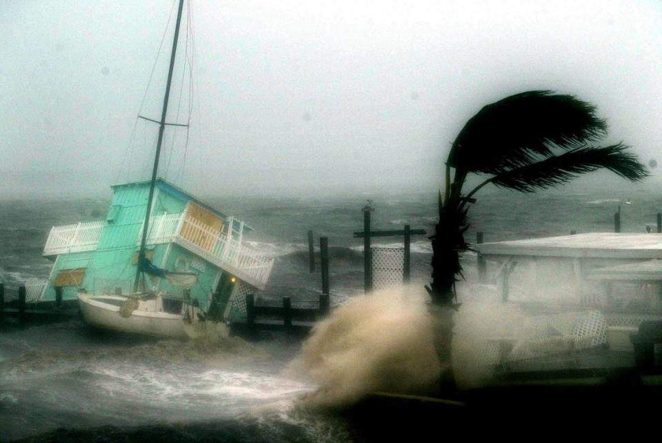
Roofs peeled off, oak trees gave up the fight against pummeling winds, and even emergency vehicles were forced off deserted, rain-swept streets as Hurricane Frances began assaulting Florida’s East Coast in earnest Saturday night.
“I have seen the roofs coming off buildings,” said Doug Anderson, administrator of St. Lucie County. “I have seen siding come off buildings.”
In Fort Pierce, where a Kmart lost part of its roof and some mobile homes were reported destroyed, and in Stuart, which suffered damage to at least a dozen businesses along U.S. 1, the toll rose as the winds increased. Widespread power outages darkened the coastline from Brevard County south to Miami-Dade. Trees toppled, rain pelted in sideways sheets and flooding became a growing worry.
In shelters and boarded-up community buildings, cabin fever was replaced by sudden thankfulness for shutters and thick walls.
“I don’t like all the rattling,” said Marilyn Blauman, as another gust of wind shook the metal shutters on the clubhouse at Fairlane Mobile Home Park in Vero Beach. “It makes me think it’s coming.”
Frances was coming, finally - its leading edge spreading misery and destruction from Brevard to Palm Beach counties and beyond, its satellite picture of angry reds and oranges nearly swallowing the entire state.
And worsening weather lay ahead, with hurricane-force winds still to come for many, said Nathan McCollum, emergency management coordinator for Indian River County.
“We’re starting to have screen porches go,” he said. “It will be more frightening later.”
Still, residents used Frances’ slow approach to prepare, and that showed. Stores and houses were buttoned down, and streets were empty. In Vero Beach, a businessman protected the front of his offices with large dump trucks full of sand. Farther down the street, a sign on plywood across a garage door read: “Stand Tall and Proud - Kiss My Butt, Frances.”
Gerod Johnson, 42, a medical equipment salesman, moved to Stuart from New York and had never seen anything like a hurricane. “I’ve been here four months, and this is my introduction to Florida,” he said. “Mass destruction.”
Measuring the full extent of the damage was nearly impossible late Saturday: In Martin County, as in other places, police cars were pulled from the road during the roughest part of the storm for the safety of the officers. Emergency operations officials were hunkered down, as well.
But early reports offered preliminary information: On U.S. 1 in Stuart, winds peeled off sheet-metal roofs and tore away awnings, sending them spinning across the highway. Part of the blue metal roof on a Howard Johnson was missing.
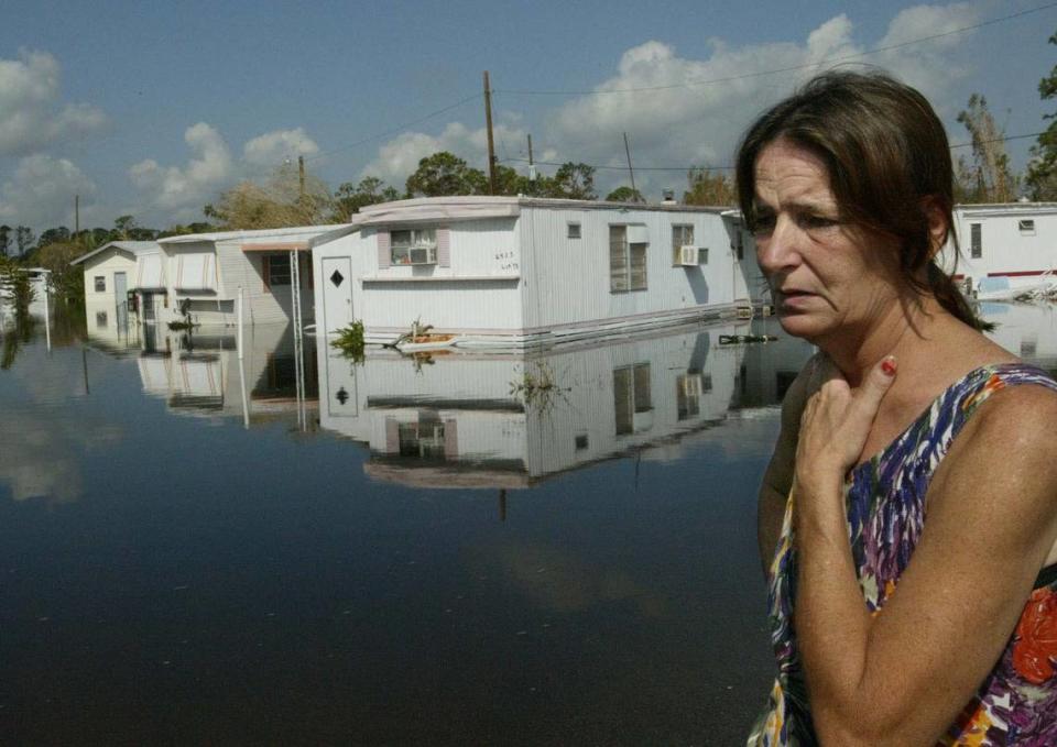
Fort Pierce lost mobile homes in Golf Village at Spanish Lakes, and roofs of mobile homes in a park on the causeway of South Hutchinson Island were gone by Saturday night.
“East of U.S. 1 in Port St. Lucie had been hit real hard,” said Fort Pierce police spokeswoman Audria Moore.
One person in a shelter was reported dead. A 94-year-old woman who had been fighting liver cancer died at a special-needs shelter in Brevard County Saturday afternoon, according to Joan Heller, a spokeswoman for the emergency operations center.
Also in Brevard, wind gusts demolished a trailer in the Snug Harbor mobile home park and wind damaged the roofs of four others.
Three people in Palm Beach County were hospitalized for poisoning from gas-run generators, and the roof on the Avalon Assisted Living Center near Lake Worth was damaged, forcing the evacuation of 112 patients. Hangars at the county’s airport, the Lake Worth Pier and numerous marine yards were damaged, as well.
As the eye wall brushed Palm Beach late Saturday night, bending trees at extreme angles, county public affairs director Beth Ingold-Love, working at the county’s emergency operations center, choked up. Construction had almost finished on her house near Jupiter Inlet, she explained, and now it was likely a total loss.
In St. Lucie County, damage reports included the Notre Dame Mission on U.S. 1 and several restaurants in the area. Indian River Drive was closed near the Martin-St. Lucie County line for flooding, and the public works department lost part of its roof.
Winds howled, but it was rain that worried others. As relentless sheets fell outside, Shaniecie Suttle, her three children and a nephew watched worriedly from their second-floor hotel room at the Holiday Inn Express in Fort Pierce. Her mother and sister already had moved there from a first-floor room as water topped the grass and crept toward the rooms.
“That’s what we’re scared of here, the flooding,” she said. “We’re worried about the house. It’s real low.”
Power outages, too, grew as the hours passed. Not even shelters were immune. Red Cross officials reported two shelters without power Saturday evening in Brevard.
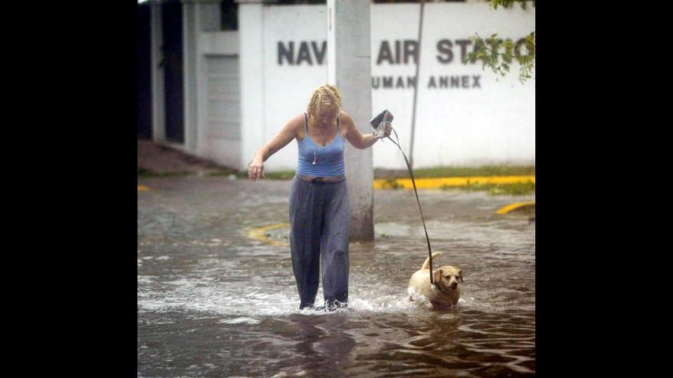
Hurricane Ivan
High storm cycle is here to stay
Published Sept. 8, 2004
Charley, Frances and Ivan. Three major hurricanes. Two assaults on Florida already and possibly a third by next week. Get used to it. This is the new normal.
Scientists say we are in a period of enhanced hurricane activity that could last for decades, ending a 24-year period of below-average activity. They also say the law of averages has caught up with Florida, with a change in atmospheric steering currents turning the state into a hurricane magnet.
“People are suddenly alert, suddenly paying attention,” said Stanley Goldenberg, a meteorologist with the National Oceanic and Atmospheric Administration’s hurricane research division on Virginia Key. “They can see now that we are in an active era. . . . People should realize that it is very unlikely that Frances is the last storm the U.S. will see this year.”
Which brings us to Hurricane Ivan.
Though subject to considerable error, long-range forecasts are consistently suggesting that Ivan will strike Jamaica on Friday and Cuba on Sunday as a vicious Category 4 hurricane. After that, the outlook is unclear, but the Tuesday night forecast placed much of the state in the five-day cone of probability.
When asked if Florida could endure another hurricane, Gov. Jeb Bush pointed Tuesday to a button he wore on his shirt. It read: “I survived damn near everything.”
“We will survive whatever comes at us,” he said. “We’re an incredibly resilient state. I’m not being defiant; I’m only suggesting we can meet this challenge.”
Hurricane Jeanne
We’ve had enough as fourth storm blasts reeling state
Published Sept. 26, 2004
It didn’t seem possible, and it certainly didn’t seem fair, but Hurricane Jeanne blasted ashore Saturday night along Florida’s Treasure Coast - bulldozing the same area, terrifying the same people humbled just three weeks ago by Hurricane Frances.
Jeanne’s mighty eye wall struck Stuart, Fort Pierce and Vero Beach around 10 p.m. The official point of landfall for the eye itself was on Hutchinson Island — at precisely the same latitude and longitude as Frances’ landfall: 27.2 north, 80.2 west. Official time: 11:50 p.m.
The wide, calm eye brought respite, but it was temporary and deceptive:
The storm raged as a Category 3 hurricane with 120-mph winds capable of inflicting enormous damage, and the second half was right behind that eye.
Wind gusts overturned cars and blew others off the road in Palm Beach County. Martin Memorial Hospital North in Stuart lost some of its roof. A stretch of Vero Beach’s oceanfront street crumbled into the sea.
Once again this morning, a hurricane disaster was in the making in Florida. It was the fourth time this year. Never before has that happened since record-keeping began in 1851.
“Who’d believe it?” Greg Vafiades of Sebastian, near Vero Beach, said Saturday night as Jeanne punched repeatedly at what Frances left of his home. “It’s odds you couldn’t even imagine.”
The eye wall was heralded and followed by hours of whistling, howling wind and cascades of rain and intensifying apprehension.
Some wind measurements or estimates: 110 mph in Vero Beach, 100 mph in Jupiter, 93 mph at Sebastian. In South Florida, winds or gusts of 61 mph were reported in Pompano Beach, 60 mph in Fort Lauderdale, 44 mph in Opa-locka, 35 mph in Miami.
Residents of Pompano Beach, Deerfield Beach and Oakland Park reported downed trees, power lines and damaged roofs.
Along the Treasure Coast - the region between Palm Beach and Cape Canaveral - bombardments of wind propelled by this new curse called Jeanne lifted and catapulted debris from the previous curse called Frances, creating jagged missiles that in turn created a new generation of debris.
No casualties were immediately confirmed, and damage reports were sketchy, but the storm still raged and the tolls in human suffering and physical destruction could be high.
Two initial indications: The U.S. Coast Guard searched fruitlessly for a surfer reported missing off Miami Beach, and police said a vehicle trying to cross a closed bridge in Fort Pierce went airborne and disappeared in the Indian River Lagoon.
Another indication: State officials estimated that Jeanne could damage 1 million buildings - some destroyed, some marred - and displace 223,000 families.
And another: Hundreds of thousands of Florida Power & Light customers were without power, including 94,000 in Palm Beach County, 70,000 in Broward County and 6,500 in Miami-Dade County.
Jeanne still raked South and Central Florida with its rear half this morning, even as its front half and eye wall roared diagonally through Florida’s peninsula, tormenting new victims.
Intense weather rolled through Broward and, to a lesser extent, Miami-Dade, compelling millions of people to shutter themselves inside their homes once again or retreat to public shelters or inland refuges.
Forecasters said Broward residents could expect strong wind throughout today, and six to eight inches of rain by Monday. Miami-Dade residents should expect three to six inches of rain.
As the storm approached, South Floridians searched for gasoline, made other last-minute preparations and then rode it out - in some cases, displaying signs of stress.
The Broward Sheriff’s Office was bombarded by people calling 911 for information. Officials pleaded with residents to keep those lines open for true emergencies.
To the north, it was much worse.
A four-to-seven-foot storm surge and much higher waves crashed ashore along the Treasure Coast.
Lightning illuminated the sky with an eerie green strobe-like effect in Martin County, where several roads were flooded and emergency crews were ordered off the streets.
Road signs cartwheeled across highways, and sheet metal hurdled into nearby walls in St. Lucie County.
In Vero Beach, coastal areas took a major hit.
“Water is washing over the dune and washing over Ocean Drive,” Vero Beach Police Chief Jim Gabbard said. “A lot more of the road has gone.”
Siding peeled off a beachfront condo complex heavily damaged by Frances, he said, and post-Frances debris catapulted through the air. “It is pretty hazardous out there,” he said.
And they went through this so recently along the Treasure Coast.
So many deroofed houses had been covered with flimsy plastic sheets, so many plans and dreams shattered, so many lives disrupted, so many people just starting to recover, and now . . . this.
“My heart goes out to those people,” said Max Mayfield, director of the National Hurricane Center in West Miami-Dade County, whose house was damaged by Hurricane Andrew in 1992. “The recovery phase is difficult . . . then to have another storm on top of it.”

