Stunning satellite images show just how big Death Valley’s lake really was. See them
Visitors to Death Valley National Park have had more time to see the park’s temporary lake than experts estimated, and photos on social media show the lake is still going strong.
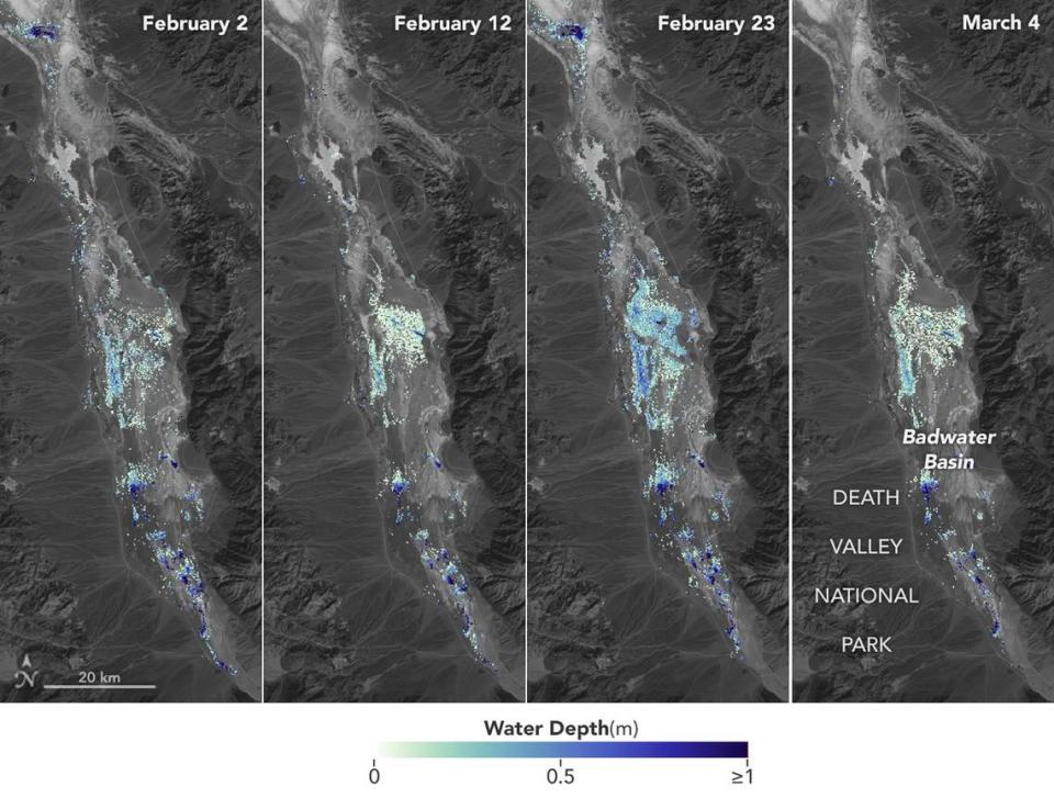
Now new satellite images from NASA show the rare lake in the middle of the desert in California was actually quite a bit deeper than previously thought — which might explain its staying power.
Park officials said the lake on the valley floor of Badwater Basin — the lowest and driest point in North America — was about 2 feet deep at its largest, according to a Feb. 8 news release.
NASA’S analysis shows the lake — known as Lake Manly — actually reached 3 feet deep at one point, officials said in an April 16 news release. It ranged between that depth and less than 1.5 feet deep over the course of six weeks in February and March.
The new satellite images show dark blue water where depths reached 3 feet.
That extra foot of water is significant because Badwater Basin is typically a cracked, bone-dry salt flat. And since there isn’t usually a lake there, “researchers don’t have permanent instruments in place for studying water” in the area, officials said. But for a few weeks in February, the lake was deep enough to kayak across, McClatchy News previously reported.
“This is a really cool example of how SWOT can track how unique lake systems work,” said Tamlin Pavelsky, NASA’S lead freshwater scientist for the satellite and a hydrologist at the University of North Carolina, Chapel Hill.
“SWOT can fill the data gap for when places like this, and others around the world, become inundated,” researchers said.
Researchers calculated its depth by measuring the lake’s water levels from space using its Surface Water and Ocean Topography (SWOT) satellite, then subtracting corresponding U.S. Geological Survey land elevation data for Badwater Basin, officials said.
Experts estimated — correctly — that the lake’s waters would stick around long enough to create beautiful reflections of the surrounding mountains through April.
Photos posted to Reddit show those estimations were correct. Clear water still sits over the salt flat in the photos.
“Lake still going strong (though probably not for much longer),” someone wrote in the DeathValleyNP subreddit on Saturday, April 20.
Stunning satellite images show a rare lake in Death Valley National Park. Take a look
Death Valley’s temporary lake is so deep, you can kayak on it — and some have. See it
‘Entire lake’ migrates 2 miles north when strong winds hit Death Valley, officials say

